- CURRENT LOCATION: HOME
- >> About Shaanxi
- >> Global Associations
- >> Sister Cities
- >>
- Shaanxi
Umbria(Italy)
2017-04-10 16:00:05 , Source : The Government Website of Shaanxi Province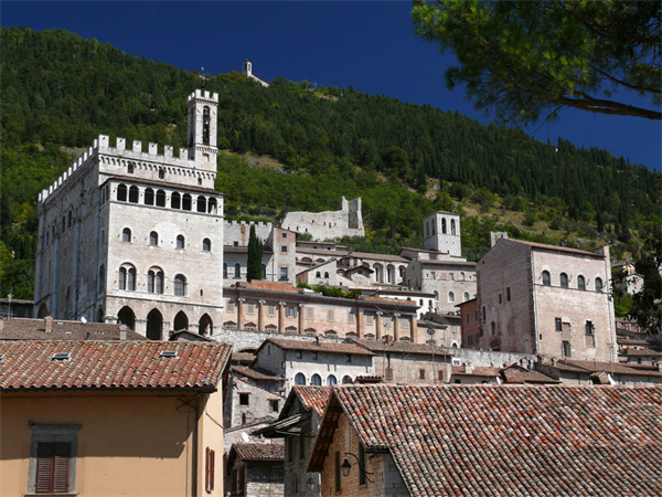
Umbria is a region of historic and modern central Italy. It is the only Italian region having neither a coastline nor a border with other countries. It includes the Lake Trasimeno, Marmore's Falls, and is crossed by the River Tiber. The regional capital is Perugia. Umbria is known for its landscapes, traditions, history, culinary delights, artistic legacy, and influence on culture.
The region is characterized by hills, mountains, valleys and historical towns such as Perugia (known as an important university centre), Assisi (a World Heritage Site associated with St. Francis of Assisi, the Basilica of San Francesco and other Franciscan sites, works by Giotto and Cimabue), Terni (the hometown of St. Valentine), Norcia (the hometown of St. Benedict), Città di Castello, Gubbio, Spoleto, Orvieto, Castiglione del Lago, Narni, Amelia, and other small cities. Contained within Umbria is Cospaia, a tiny republic created by accident that existed from 1440 to 1826.
Geography
Umbria is bordered by Tuscany to the west, Marche to the east and Lazio to the south. Partly hilly and mountainous, and partly flat and fertile owing to the valley of the Tiber, its topography includes part of the central Apennines, with the highest point in the region at Monte Vettore on the border of the Marche, at 2,476 metres (8,123 feet); the lowest point is Attigliano, 96 metres (315 feet). It is the only Italian region having neither a coastline nor a common border with other countries. The commune of Città di Castello has an exclave named Monte Ruperto within Marche.
Umbria is crossed by two valleys: the Umbrian valley ("Valle Umbra"), stretching from Perugia to Spoleto, and the Tiber Valley ("Val Tiberina"), west of the first one, from Città di Castello to the border with Lazio. The Tiber River forms the approximate border with Lazio, although its source is just over the Tuscan border. The Tiber's three principal tributaries flow southward through Umbria. The Chiascio basin is relatively uninhabited as far as Bastia Umbra. About 10 kilometres (6 miles) farther on, it joins the Tiber at Torgiano. The Topino, cleaving the Apennines with passes that the Via Flaminia and successor roads follow, makes a sharp turn at Foligno to flow NW for a few kilometres before joining the Chiascio below Bettona. The third river is the Nera, flowing into the Tiber further south, at Terni; its valley is called the Valnerina. The upper Nera cuts ravines in the mountains; the lower, in the Tiber basin, has created a wide floodplain.
In antiquity, the plain was covered by a pair of shallow, interlocking lakes, the Lacus Clitorius and the Lacus Umber. They were drained by the Romans over several hundred years. An earthquake in the 4th century and the political collapse of the Roman Empire resulted in the refilling of the basin. It was drained a second time, almost a thousand years later, during a 500-year period: Benedictine monks started the process in the 13th century, and the draining was completed by an engineer from Foligno in the 18th century.
The eastern part of the region, being crossed by many faults, has been often hit by earthquakes: the last ones have been that of 1997 (which hit Foligno, Assisi and Nocera Umbra) and those of 2016 (which struck Norcia and the Valnerina).
Folklore
One of the most important festival in Umbria is the festival of the Ceri in Gubbio, a run held every year always on the 15th day of May from 1160, in which three teams, devoted to St. Ubaldo (the patron saint of Gubbio), S. Giorgio, and S. Antonio, run through throngs of cheering supporters (clad in the distinctive colours of yellow, blue and black, with white trousers and red belts and neckbands), up much of the mountain from the main square in front of the Palazzo dei Consoli to the basilica of St. Ubaldo, each team carrying a statue of their saint mounted on a wooden octagonal prism, similar to an hour-glass shape 4 metres tall and weighing about 280 kg (617 lb).
The race has strong devotional, civic, and historical overtones and is one of the best-known folklore manifestations in Italy; the Ceri were chosen as the heraldic emblem on the coat of arms of Umbria as a modern administrative region.
Economy
The present economic structure emerged from a series of transformations which took place mainly in the 1970s and 1980s. During this period, there was rapid expansion among small and medium-sized firms and a gradual retrenchment among the large firms which had hitherto characterised the region's industrial base. This process of structural adjustment is still going on.[5]
20-25% of Umbria's GDP is represented by Terni steelworks (stainless steel, titanium, alloy steel) and the processing companies (automotive, staninless steel tubes, industrial food facility). In Terni there are also many multinational companies in the branch of chemistry, hydroeletric, renewable energies, textiles (Alcantara). In the rest of Region, ornamental ceramics industry is very esteemed.
Umbrian agriculture is noted for its tobacco, olive oil and vineyards, which produce excellent wines. Regional varietals include the white Orvieto, which draws agri-tourists to the vineyards in the area surrounding the medieval town of the same name. Other noted wines produced in Umbria are Torgiano and Rosso di Montefalco. Another typical Umbrian product is the black truffle found in Valnerina, an area that produces 45% of this product in Italy.
The food industry in Umbria produces processed pork-meats, confectionery, pasta and the traditional products of Valnerina in preserved form (truffles, lentils, cheese).

Government Organizations

Other Links

Copyright@www.shaanxi.gov.cn All Rights Reserved
Registration Number:陕ICP备10004160号