- CURRENT LOCATION: HOME
- >> About Shaanxi
- >> Global Associations
- >> Sister Cities
- >>
- Baoji
Yawata (Japan)
2017-04-26 09:23:00 , Source : The Government Website of Shaanxi Province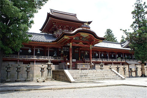
A stone implement about 20,000 years before is unearthed from the southwest hills in a municipal area in the old days for Hachiman's history, and it's asked that a person was living in the Paleolithic era already. Yawata shows that the remains of the Yayoi Era and the tumulus period was distributed over municipal area entire area and open from antiquity.
Use in a channel of Kizu-gawa and Yodogawa rose as transportation as well as until Yawata came in the modernized world from antiquity old Sanin-expressway, Higashi-koya highway and Kyokaido were maintained as a land route, and the this city was being charged with the important role as an important point of traffic which leads to the San-in region, Nara and Kyoto.
To guard the Jougan first year (859) and the Heian castle town, from Kyushu, Japanese Mars, kansei, it's developed as the cathedral town after Iwashimizu-hachimangu is built in Otokoyama.
Shokado akirajou called three brushes of one person in beginnings and Kanei in the Edo Period lived in bousha in Iwashimizu-hachimangu and gathered round with contemporary famous literati in a cultural face, and the high status was also occupied as a cultural sending base through calligraphy, a tea ceremony and a 31-syllable Japanese ode.
Development of farm produce and cultivation become popular from the Edo Period to the Meiji period, and it's also developed as the neighboring farm they feel hold a big consuming region as Kyoto and Osaka and the abundant country is wide where. There was no scale-like expansion as a cathedral town, but the stable development was being also continued in commerce.
A railroad through a northern end in a municipal area opened to traffic in the last years in Meiji, and the role of Motoichi as an important point of Yodo-gawa water transportation fell gradually with development of transportation.
Hachiman-cho, Tsuzuki village and Uchigou village were provided by Town and Village Organization Law operation for the present municipal area in 1889, and these 3 towns and villages merged in 1954, and it was Hachiman-cho with 16,000 people of new population.
The population carried out City Organization Law on November 1, 1977 beyond 50,000 people (national census) in 1975, and the Yawata city which becomes the 11th city in the Kyoto was born. The population growth was also continued after that and it was 76,467 people current as of the last day of January, 1993, after a while dwindles peaking at this, at present, about 73,000 people, Yawata is changing.
Geography
This city is located in the spot where the southwest of Kyoto and Mikawa in Kizu-gawa, Uji-gawa and Keisen will join and be Yodogawa, and I touch Sakai of Osaka-fu. Traffic possesses convenient locational condition in the middle of two great cities called Kyoto-shi and Osaka-shi.
The area is 24.35 square kilometers, and the biggest width is about 6.7 kilometers of east and west and about 8.5 kilometers of north and south, and I possess a scattered territory in the area of Kyoto-shi, Kumiyama-cho and Kyotanabe-shi.
Shimamoto-cho, Oyamazaki-cho, Kyoto-shi, Kumiyama-cho, Joyo-shi and southeastern area touch Kyotanabe-shi and Nishibe touches Hirakata-shi from the north to the east.
Other areas are formed at a plain for the most part at the hills heaved gently from Otokoyama in the west to a southern Minoyama area. Daiya-gawa in a first-grade river and prevention Kagawa flow to level terrain also the country spreads from a central part to the east.
The climate is mild relatively through the year, annual mean air temperature is 15-16 times, and precipitation is an average of about 1500 millimeters a year.

Government Organizations

Other Links

Copyright@www.shaanxi.gov.cn All Rights Reserved
Registration Number:陕ICP备10004160号